Born in 1965 in Grenoble (FR). Lives and works in Paris (FR)

2008
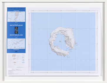
Topographic map, print on paper.
Created for CAC Vilnius, Platform grand est,
66 x 90 cm
Year of Purchase: 2011
Deception Island (62°57°S 60°36°W) is located at the gates of the Antarctic Peninsula. Of volcanic origin, the largest portion of its topography is composed of a central bay accessible by sea through a narrow strait.
The origin of its name is steeped in legend. The island was discovered in November 1820 by an American sailor Nathaniel Palmer. The English word “deception” is a false cognate in French. Far from invoking French romantic disenchantment, it signifies an act of deceit and double-dealing. Perhaps the word refers to the gloomy aspect of the shores covered with black sand, or to the perilous, hidden passageway into the bay, further obstructed by a rocky ridge running along the center, right beneath the water’s surface. Whatever the case may be, the name cannot but remind us of the persistently utopian and deceptive character of the adventure, of the
conquest of the self and of the world, where reality does not always live up to the imagination.
A number of David Renaud’s works take on the form of maps, scale models, or relief models, gradually composing a multiform atlas. There is no need for a fanciful land to spur our imagination. The artist is content with making us (re)discover inhabited or desert spaces “where nothing ever takes place but the inexhaustible and never realized field of possibilities”1; letting us dream of destinations with evocative names; leaving us to give body and meaning to solid colors, infinite spaces, to the gaps and holes, all of which bring to mind some human story.
Renaud’s Deception Island also derives inspiration from Edgar Allan Poe’s Narrative of Arthur Gordon Pym, an adventure novel published in 1838 as an account of an authentic expedition to the South Pole, and an inexorable tragic quest of a dreamer engulfed in his own phantasms. In Poe’s times, the most fabulous theories circulated concerning the existence and the nature of the poles. Poe was moreover fascinated by Symmes’ theory of concentric spheres (1826) which stated that “the earth was composed of five hollow concentric spheres, and a polar opening 4,000 miles in diameter assured the passage of water. Although the opening was surrounded by ice, the interior was hot thanks to the central fire. This explained the existence of the Gulf Stream, among other things”2. Poe was often criticized for the fanciful nature of his story: the closer his sailors got to the South Pole, astonishingly the hotter the sea and the atmosphere became. And yet Deception Island is famous precisely for its geothermal activity where the temperature may reach up to 70°C, and where reality surpasses our imagination…
Eléonore Jacquiau Chamska
To learn more about the artist: David Renaud. Paris: Éditions de l’oeil, 2009.
1 Jean-Yves Jouannais. “David Renaud. De la cartographie comme cartomancie” in:
David Renaud. Paris: Éditions de l’oeil, 2009.
fn2. Cf. Jacques Cabau. “Preface” in: Edgar Allan Poe. Aventures d’Arthur Gordon Pym.
Paris: Gallimard folio, 2007.